


Le pic de bure

raygautier
User
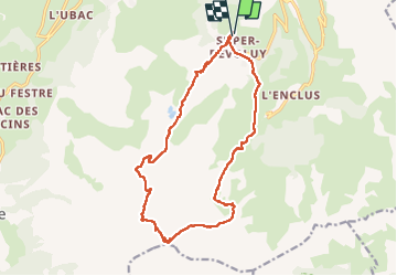

Length
17.5 km

Max alt
2590 m

Uphill gradient
1186 m
Km-Effort
33 km

Min alt
1475 m

Downhill gradient
1188 m
Boucle
Yes
Creation date :
2022-09-08 05:59:15.0
Updated on :
2022-09-09 18:50:58.2
5h14
Difficulty : Very difficult

FREE GPS app for hiking
 SityTrail
IGN / Geographical institutes
SityTrail Plus
The world is yours!
About
Trail Walking of 17.5 km to be discovered at Provence-Alpes-Côte d'Azur, Hautes-Alpes, Le Dévoluy. This trail is proposed by raygautier.
Positioning
Country:
France
Region :
Provence-Alpes-Côte d'Azur
Department/Province :
Hautes-Alpes
Municipality :
Le Dévoluy
Location:
Saint-Étienne-en-Dévoluy
Start:(Dec)
Start:(UTM)
732110 ; 4951535 (31T) N.
Comments